 Today at The Junto, Philippe Halbert interviews Erin M. Greenwald about her exhibition, New Orleans, the Founding Era, on view at The Historic New Orleans Collection through the 27 of May. Edited by Greenwald, the accompanying English-French publication features interdisciplinary essays by eight leading scholars and an illustrated catalogue. Before beginning as Curator of Programs at the New Orleans Museum of Art in 2017, Greenwald was senior curator and historian at The Historic New Orleans Collection, where she curated exhibitions including Purchased Lives: The American Slave Trade from 1808 to 1865, a traveling exhibition funded by the NEH and awarded the AASLH Leadership in History Award of Merit. Her first monograph, Marc-Antoine Caillot and the Company of the Indies in Louisiana: Trade in the French Atlantic World, was published by LSU Press in 2016. Greenwald also chairs the New Orleans Slave Trade Marker and App Project, an initiative of the 2018 Tricentennial Commission, which anticipates placing six interpretive markers designating sites in New Orleans with direct links to the slave trade this summer.
JUNTO: Congratulations, Erin, on New Orleans, the Founding Era, and thank you for agreeing to talk to us about the exhibition and book! 2018 marks the tricentennial of the founding of New Orleans by the French. How have you defined this “founding era” date-wise?
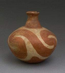
Nodena red and white bottle; 1540-1700; ceramic, pigment; Edwards Mound, Coahoma County, Mississippi, 22CO503; Peabody Museum, Harvard University.
GREENWALD: The exhibition’s chronology focuses primarily on the first half of the 18th century, though in both the exhibition catalogue and the galleries we look back to earlier centuries to better understand not only New Orleans’s foundation but the cultures that came before. The earliest objects in the exhibition—a group of Mississippian effigy pots that date to around 1400—are intended to reinforce visitors’ understanding of the Lower Mississippi Valley as a vibrant and fully inhabited space in the precolonial era.
JUNTO: Bourbon Street, Jackson Square, and other iconic spots in the French Quarter continue to shape impressions of New Orleans today. Regrettably, a significant amount of colonial-era New Orleans architecture has been lost—to disastrous fires in 1788 and 1794, the effects of local weather conditions, and urban development—over the centuries. What did New Orleans look like in the founding era, just how “French” was it, and what kinds of sources did you use to evoke the early cityscape in the exhibition?
GREENWALD: One of the greatest joys in compiling this exhibition was the opportunity to bring together in a single space disparate types of objects—from maps and plans to narrative accounts, scientific instruments, and archaeological artifacts—that help us construct a fuller, more nuanced understanding of early New Orleans. In some ways, especially on paper, New Orleans was the epitome of Enlightenment ideals that called upon French military engineers to create an ordered, rectilinear grid whose streets marched forth from perfectly proportioned blocks and whose extremities were bounded by well-defined ramparts. The reality of course was more complicated.
There is a series of three maps included in the exhibition that speaks to the tension between engineers’ aspirations and the realities of carving out a settlement from what was chiefly wilderness. The first, drawn by engineer Louis-Pierre Leblond de La Tour in January of 1723, is the earliest extant plan in which the grid we now know as the French Quarter is recognizable. Likely based on Adrien de Pauger’s original 1721 plans for the settlement, La Tour’s plan identifies two swaths of land along the river stretching from Saint Ann to the block between Bienville and Conti Streets that were presumably the first areas cleared under the direction of the city’s founder, Jean-Baptiste Le Moyne de Bienville, in 1718. The plan then identifies—in a green watercolor wash—a more substantial area of land identified as “newly cleared.” The perimeter, including everything beyond Bienville and Bourbon Streets, remains forested, though the familiar grid lines peak out from beneath the trees.
The second map, completed a little more than two years later in May 1725 and thought to be the work of Pauger, suggests a far more advanced settlement project complete with a fully cleared sixty-six block grid, ramparts, and a projected canal. The only trees shown here are outside the cleared grid, and all of the streets are not only delineated but also named. By contrast, the December 1731 plan drawn up by Claude Gonichon shows Bourbon Street as the last named street running parallel to the river and makes clear that the cleared footprint was much smaller than what was shown in the 1725 plan. Gonichon’s depiction aligns more readily with census records, too, in which the street we now know as Dauphine is identified as “the street facing the woods.”
Beyond the realm of official maps and plans though, the question of what New Orleans “looked like” is something we should think about not only within the context of the built environment but also of the population living, working, and trading in as well as visiting the settlement. Watercolor drawings, like those created by Alexandre de Batz and Jean-Pierre Lassus, and narrative accounts by the Ursuline nun Marie-Madeleine Hachard Antoine-Simon Le Page du Pratz, Jean-François Benjamin Dumont de Montigny, and Marc-Antoine Caillot help us fill in details within our imagined understanding of what New Orleans was in the founding era. Taken with archaeological artifacts recovered during excavations of French colonial-era sites across the French Quarter, a picture of the settlement emerges, and it is one marked by an incredibly diverse array of Native, African, and European cultures.
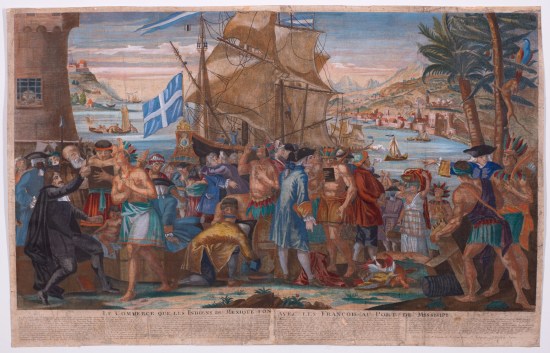
Le commerce que les Indiens du Mexique font avec les François au port de Missisipi; 1719-1721; hand-colored copperplate engraving; François-Gérard Jollain; The Historic New Orleans Collection, 1952.3
JUNTO: As an historian, what drew you to Louisiana in the first place, and what has been your experience working on the history of the early Gulf South?
GREENWALD: I grew up just down the coast in Pensacola, Florida. Every summer in the depths of August, we were that family that took advantage of rock-bottom hotel rates to visit New Orleans. Never mind that the reason it was so affordable was that New Orleans in August is a steamy, oppressively hot, and sometimes smelly place; I loved it. I’ve felt more at home and more curious about this city, its history, and its inhabitants than any other place I’ve lived or visited for as far back as I can remember. When I was at Tulane as an undergraduate in the 1990s, it was considered gauche and provincial to study Louisiana history. In fact, the only Louisiana history classes offered by Tulane’s history department at the time were night classes available through what was then known as University College—an extension program designed primarily for athletes and continuing education learners. I took them anyway and found the content reinforced my desire to better understand this place. Ultimately I went on to pursue a PhD in history, and by the time I completed my degree, the field of early American history had changed considerably, becoming much more inclusive and representative of geographies outside the bounds of the thirteen British colonies.
Louisiana history, in particular, benefited greatly from the Atlantic turn. When I was working on my first major colonial Louisiana project, A Company Man: The Remarkable French-Atlantic Voyage of a Clerk for the Company of the Indies, an annotated, translated edition of the journal of Marc-Antoine Caillot owned by The Historic New Orleans Collection, I began to really understand the richness of colonial Louisiana’s documentary record. Through that project it also became clear how important it was to study colonial Louisiana within the broader contexts of not only French Atlantic history but also within the context of global trade. There is a bright line between that original project and my subsequent work, including New Orleans, the Founding Era as well as the 2013 Historic New Orleans exhibition Pipe Dreams: Louisiana under the French Company of the Indies, 1717–1731 and my 2016 monograph Marc-Antoine Caillot and the Company of the Indies in Louisiana: Trade in the French Atlantic World (LSU Press).
JUNTO: What were your goals for New Orleans, the Founding Era?

Free-blown wine bottle; 1725-1750; France; glass; recovered from 400 Chartres Street, 16OR467; The Historic New Orleans Collection, 2014.0008.2.1
GREENWALD: New Orleans, the Founding Era offers visitors an opportunity to reflect on the complicated and often messy nature of New Orleans’s birth and early years. As a curator, my goal is to help visitors better understand the settlement’s development from a swampy backwater, home to a handful of rough-hewn structures and a number of equally rough inhabitants, to a cultural and economic crossroads designed by royal engineers and shaped by a kaleidoscopic array of influences. Key to this goal is an examination of the lived experiences of the settlement’s earliest inhabitants, a majority of whom, including French and Canadian soldiers, French convicts, and enslaved Africans, were unwilling participants in France’s colonization of the Lower Mississippi Valley.
JUNTO: On the subject of early immigration, settlement, and slavery in Louisiana, the figure of Marie Baude emerges as an especially compelling figure in both the catalogue and the exhibition. Can you summarize her story for us?
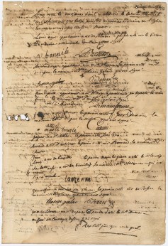
Baptismal record for twelve enslaved adults; April 12, 1732; folio 23, SLC Baptisms Book A, 1731-33; courtesy of the Archdiocese of New Orleans, Office of Archives
GREENWALD: I first learned about Marie Baude from Jessica Marie Johnson. In 2013 Johnson, who at the time was still a grad student, gave a paper at the AHA in New Orleans about this fascinating Senegalese woman—a free woman—who traveled to Louisiana in 1728. In the exhibition, we included Marie Baude as one of eight inhabitants of colonial New Orleans featured in what we call “talking silhouettes.” These are short videos shot with live actors in silhouette with audio narration that either tells the story of an individual based on archival records or uses primary accounts to have an individual provide their own narrative. For Marie Baude we included the following mini-biographical portrait:
Marie Baude boarded the slave ship Galathée at Gorée Island, off the West African coast, on October 21st, 1728. She joined the crew and four hundred enslaved men, women, and children, including three people she claimed as her own property. But although she was from Africa, Marie Baude was not a captive. She was a free Senegalese woman whose voyage was voluntary, not forced. She left Senegambia to join her husband Jean Pinet, a French gunsmith exiled to Louisiana as punishment for murder.
Traveling by boat across the Atlantic was never an easy journey, and the Galathée’s crossing was exceptionally dangerous. Sickness and death set in within days of sailing, chasing the ship across the ocean, through the Caribbean, and into the Gulf of Mexico. When the Galathée anchored off Louisiana’s coast seven months later, Baude had survived the voyage. Eighty-two enslaved people and eleven crew members had not.
Because interactive content for exhibitions usually needs to be quite brief, we were unable to include details about Marie Baude’s experiences once she arrived in Louisiana. But those details are equally compelling. When she arrived—with three people she claimed as her own property—she was found to be in violation of the Company of the Indies’ monopoly on the slave trade. Her slaves were impounded and she became entangled in a protracted battle to recover them.
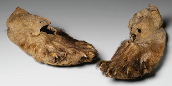
Bear paw moccasins; 18th century; Louisiana; bear and deerskin; courtesy of the musée du quai Branly-Jacques Chirac, 71.1934.33.13.1-2 D
JUNTO: The exhibition features a wide range of archival documents, artifacts, maps, and works of art from public and private collections across North America and Europe. I was amazed to see familiar architectural elevations and plans in a way that allowed me to appreciate their artistry and physical scale in new ways. The pair of 18th-century bear paw mocassins, once part of a collection used to teach French princes at Versailles, was also a highlight (you really have to see them in-person!). What can you tell us about your favorite piece in the exhibit?
GREENWALD: The 1726 panoramic view of New Orleans and the Company of the Indies plantation (on the land now called Algiers Point), on loan from the Archives nationales d’outre-mer in Aix-en-Provence, France, is one of the most visually stunning and historically important objects in this exhibition. Created by the French surveyor Jean-Pierre Lassus, this earliest known pictorial view of New Orleans provides an intimate view of the settlement in its infancy. The Mississippi River dominates the scene with a bustling port shown at center. On the other three sides, the town appears hemmed in by dense wilderness. A path through the trees at the rear of the settlement suggests connections to Bayou St. John, Lake Pontchartrain, and beyond. And in the foreground, Lassus provided visual clues about the colony’s bound labor force, zooming in to show enslaved African men clearing land on the company’s plantation.
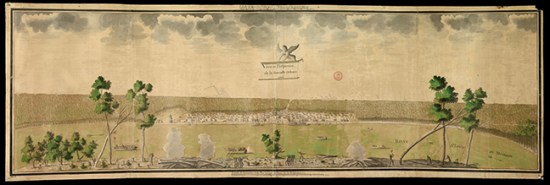
Veüe et perspective de La Nouvelle-Orléans [View and perspective of New Orleans]; 1726; ink and watercolor; Jean Pierre Lassus; courtesy of the Archives nationales d’outre-mer, Aix-en-Provence, France, ANOM 04DFC 71A
JUNTO: Worth noting is that the Lassus panorama is just under 5 feet in length! One last question, but if you could offer one takeaway from New Orleans, the Founding Era for scholars interested in colonial Louisiana and for early Americanists writ large, what would it be?
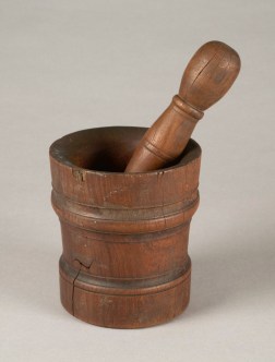
Mortar and pestle used by Sister Francis Xavier Hébert, head nurse of the royal hospital; first half of the 18th century; wood; courtesy of the Ursuline Convent Archives and Museum, New Orleans, Louisiana
GREENWALD: Don’t be afraid of straying from the documentary record, and when you think about the documentary record, be as inclusive as possible. We have a tendency as historians sometimes to rely overmuch on textual documents. Printed and manuscript materials are of course critical to our research. For the colonial period, though, in order to achieve the fullest possible understanding of time and place, we should also embrace visual sources, including maps, plans, paintings, and drawings. Material culture artifacts, too, whether they’re pristine examples of 18th-century furniture or textiles, or grimy fragments of ceramics unearthed via archaeological excavations, can help us fill in the narrative and further our understanding of the lived experience of those inhabiting colonial Louisiana.

Pingback: New Orleans at 300: A Year in Review and a Look to the Future « The Junto