 It’s time we remake the North American map.
Open up most any early American history book and flip to the list of tables and figures. Chances are you’ll find—if provided—maps devoid of almost any indigenous peoples. If the book is more recent, perhaps instead you’ll find that the author included two maps: one of European settlements, and one of Native American peoples. Or, just maybe, you happen to have on hand one of the few books to merge all of these together. But look closely and see if you can find the usual tension—an unbalance resulting from the projection of European empire on one hand, and the illustration of limited, isolated, scattered indigenous nations on the other.
How can so many maps of colonial North America display European power and political influence, but not do the same for American Indian polities and groups?
Maybe the better question is, how can we overcome our own historiographical strictures and the limitations of seventeenth and eighteenth-century maps to better portray the American landscape?
Fortunately, we’re at an important moment of opportunity, the confluence of two important streams of early American scholarship: First, the ever-growing body of Native American history, a literature that has increasingly pushed so-called “mainstream” history to do more than simply acknowledge indigenous peoples but even actively reconstruct indigenous polities and cultures as part of the heart of America; And second, the renewed interest in historical geography buoyed by the rising popularity of spatial history.
Over the past decade, an increasing number of works have not only taken place and geography as their major framing devices, but have done so around indigenous geographies. [1] Others have turned towards different conceptions of space and landscape, and of borders and borderlands. [2] Jon Parmenter in The Edge of the Woods, especially, has moved beyond reconstructing indigenous settlements, to examining the changing shape of Iroquoia as a distinct region, one for which geography and power were intimately linked. And yet, as James Merrell argued in his “Second Thoughts on Colonial Historians and American Indians,” in the July 2012 William and Mary Quarterly, these works still remain outliers. (Note, too, that many of the footnoted works come from beyond the discipline.) Early America still, it seems, has far to go. [3]
To move ahead, we need to do more than just simply restore the details of seventeenth and eighteenth-century static landscapes, to do more than just reinsert the locations of villages, towns, and castles and maybe provide their indigenous names. Rather, we need to go well beyond the contemporary cartography and use maps to illustrate indigenous political, military, cultural, and diplomatic reach. That is, to use maps as they were so often intended—as expressions and illustrations of power and sovereignty.
What if, instead of decrying European maps for their ethnocentrism, their errors and oversimplifications—and worse still, their erasures—we take these maps for what they should be: not demographic truth or physical reality of settlements, but rather expressions of projected territory—protected and governed and claimed by diplomatic treaties—and then of political reach? And if we acknowledge their worth on some level, can we not also use maps to depict Native America, to express indigenous political power and range?
Easier said than done. The question now is: how might we recreate these territories or spheres without relying on colonial perceptions?
First, we can take advantage of the wealth of knowledge we have of indigenous roads and pathways. Then, using documentary evidence of movement and mobility, and of trade, military, and political relationships, we can recreate patterns and scope.
Think of how a map of routes, both indigenous and European (noting that many were the same), might not only give us a better idea of dynamic interaction than would a static map of settlements, but might also give us a better sense of the furthest extents of economic or political influence of indigenous peoples. In eastern North America, pathways stretching from the Northern Great Lakes to the Southeast and Lower Mississippi Valley were far more than just switchbacks and waterways—they were the conduits for raiders, warriors, traders, scouts, and convoys, the very men and women who embodied and projected their tribe, nation, or empire’s influence.
Furthermore, by mapping indigenous and European routes together, we can better identify exactly when routes were geographically dictated, and when, conversely, routes were carved by human affairs. The result of mapping Nemacolin’s path from (present-day) Virginia to the Ohio Valley, together with Washington’s Road, Braddock’s Road, and the National Road, is to find that indigenous and European routes hardly changed over centuries. But if we look further north, to the Pennsylvania Forbes Road and the network of paths—Kittaning, Shamokin, Venango, Tuscarora, among others—that crisscrossed the same valleys and plateaus, we find something quite different. While some cut east-west (as in the case of Forbes), many more of the indigenous paths took decidedly north-south routes. It is a significant divergence, one that suggests not geography, but instead very different destinations, travelers, and political/economic/military priorities.
In short, routes allow us to move beyond the limited task of marking specific native homes, and to instead understand native spaces as governed by movement and relationships. And ultimately perhaps, by taking into account frequency of use as well as how (and by whom) each route is controlled, we can map out a range or sphere of influence.
However, how else might we recover indigenous influence on a map? I would argue that there is yet another, and arguably easier, way—using the same type of sources that helped delineate European borders: treaties and land sales.
Let’s take the example of the mid-eighteenth-century Six Nations Confederacy and the Iroquois Empire. Iroquois settlements and castles of the era are easy to place on the map from travelogues, maps, military letters, archaeological digs, not to mention the landmarks that still remain. But what of their extended territory? Can we not use the same type of sources used to help delineate European extended borders or empires–treaties and land sales?
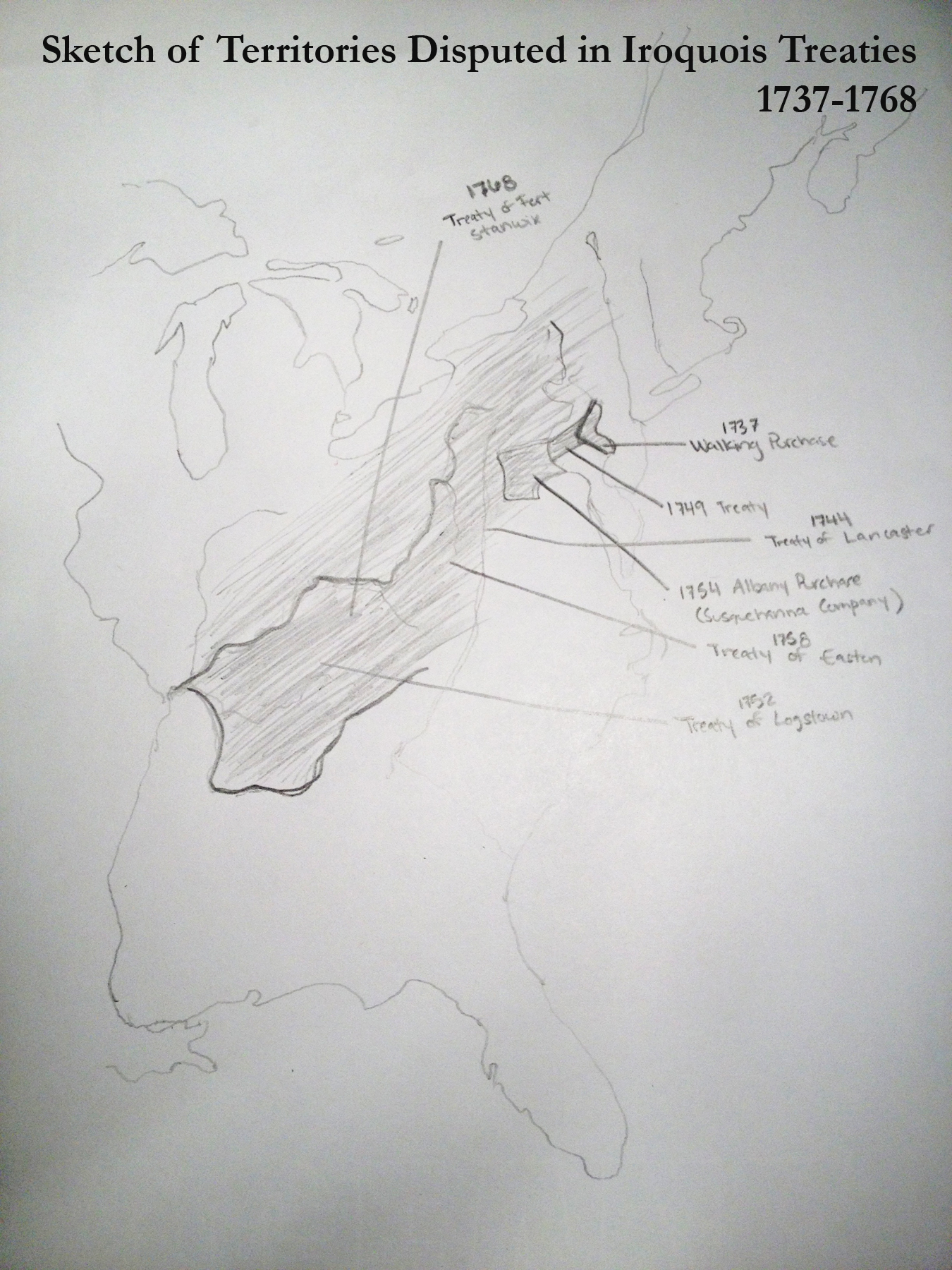 Using seven treaties and land sales from between 1737 and 1768, I’ve crudely sketched out the lands either disputed or assumed to be under Iroquois jurisdiction during this period. For each of these treaties, the Iroquois—or at least one nation of the confederacy—acted either as sole (or chief) deputy, or as a signer on behalf of another indigenous nation out of historic right of conquest. Simply signing these treaties might not signal much. But the effects of most of these treaties—notably the migration of the Lenape of the Lehigh Valley in the aftermath of the Walking Purchase—reveal that Iroquois presentation of territorial power was more than just posturing.
The idea of this exercise is not to bluntly claim that treaties bestowed true “ownership” or “control” of a region; it is to say something rather more limited: If the Iroquois were not only able to sign treaties that bore on these regions, but these agreements were widely acknowledged and adhered to—not only by the Iroquois and British, but also other indigenous groups—then the Iroquois did indeed hold some (degree) of power over that geography.
Of course, no map will ever be perfect. But if we refuse to allow for any depiction of political power over the landscape because the polity lacks complete control, or is marked by internal conflict, then we would be hard-pressed to map any nation, empire, or state. And while I do never mean to to suggest that we should draw hard borders for indigenous groups that never conceived of such, or blindly impose European conceptions of land, ownership, and sovereignty on the whole of North America, I don’t believe we can continue our limited depictions restricted to home settlements, particularly for especially mobile and powerful entities like the Iroquois or Cherokee. If, in the end, we are interested in using maps for more than just physical points, but also for representing cultural, economic, and political entities, then we need to find a way to move beyond our hesitations and fears and instead find some way to portray those fluid borders, those regions of mobility, and those ranges of influence. Until then, we still have a long way to go.
[1] Among others, see Ned Blackhawk, Violence over the Land: Indians and Empires in the Early American West (Cambridge: Harvard University Press, 2006); Matthew Dennis, Cultivating a Landscape of Peace: Iroquois-European Encounters in Seventeenth-Century America (Ithaca: Cornell University Press, 1993); Kathleen DuVal, The Native Ground: Indians and Colonists in the Heart of the Continent (Philadelphia: University of Pennsylvania Press, 2006); Jon Parmenter, The Edge of the Woods: Iroquoia, 1534-1701 (East Lansing: Michigan State University Press, 2010); David L. Preston, Texture of Contact: European and Indian Settler Communities on the Frontiers of Iroquoia, 1667-1783 (Lincoln: University of Nebraska Press, 2009).
[2] Also see Lisa Brooks, The Common Pot: The Recovery of Native Space in the Northeast (Minneapolis: University of Minnesota Press, 2008); Eric Gary Anderson, “On Native Ground: Indigenous Presences and Countercolonial Strategies in Southern Narratives of Captivity, Removal, and Repossession,” Southern Spaces (August 9, 2007); Christine DeLucia, “The Memory Frontier: Geographies of Violence and Regeneration in Colonial New England and the Native Northeast after King Philip’s War,” PhD diss., Yale University; Juliana Barr, “Geographies of Power: Mapping Indian Borders in the ‘Borderlands’ of the Early Southwest,” The William and Mary Quarterly, Third Series 68, no. 1 (2011): 5-46.
[3] James H. Merrell, “Second Thoughts on Colonial Historians and American Indians,” The William and Mary Quarterly, Third Series 69, no. 3 (2012): 451-512.

Reblogged this on Christopher P. Sawula and commented:
Great piece from Zuercher Reichardt on we can move away from the European ethnocentrism of seventeenth and eighteenth century maps to show the reach of indigenous people.
If you (and your readers) haven’t already, check out chapters nine and ten of Patricia Galloway’s Practicing Ethnohistory. The recent addition of the Georeference toolbar to ArcGIS Desktop facilitates rubbersheeting and avoids the pitfalls of “crude” sketches.
Great post! As someone who teaches the survey a lot and, more recently, American Indian History, good maps are really hard to find. I’ve taken to making a joke out of the most aggrandizing of European imperial maps, and comparing different maps of the same place at the same time to one another to illustrate the problems with the maps. I would love for there just to be more maps that represented realities on the ground as much as possible, and your suggestion of project native empires and European empires sounds great.
I would love for there just to be more maps
Cheers to that.
I would love to see a map wiki something like Google Maps but open to input from the public. It would be set up so that the user could move through time by selecting a year and seeing what people had entered in terms of communities, roads, and other features known to exist at that time. It would require fairly sophisticated software and a community of knowledgeable contributors, but if done right it could be a first step towards a clearer vision. It would also need to acknowledge the unknown without falling into the fallacy that the undocumented does not exist. Just mapping the places that are well documented would already be a big improvement over most of the maps in many books published even today.
ArcGIS for Desktop offers Explorer and a public account option. Google Earth also provides a variety of public services. Upgrades may produce mixed results and reactions, but lone additions such as a toolbar can reorganize features for accessibility.
You make a number of important points. If you (and readers of this blog) are not familiar with it, might I suggest Helen Hornbeck Tanner’s masterful study of Great Lakes Indian history. This mapping project was developed at the Newberry Library in the 1970s and it is frequently referenced to this day by scholars of Indigenous people whose work focuses on the Great Lakes and northeast.
In addition to desktop programs, LiDAR facilitates indigenous excavations of ceremonial landscapes and waterways in a limited manner. Lasers similarly map colonial places but may not chart the contraction and expansion of farmsteads and reserve boundaries. However, archaeologists apply colonial rubbersheets and secondary sources (such as the Tanner atlases) to laser surveys for synchronic and diachronic assessment.
I’m preparing to teach the survey for the first time in the fall, and I plan to begin by having the students construct maps of America, focusing at first on indigenous peoples and then gradually shifting and redrawing maps throughout the semester. This post and the comments give me lots of food for thought in this project!
Pingback: Guide to Mapping Early America with Basic GIS « The Junto