Review: Zara Anishanslin, Portrait of a Woman in Silk

Zara Anishanslin, Portrait of a Woman in Silk: Hidden Histories of the British Atlantic WorldNew Haven: Yale University Press, 2016.

A silk worm begins wrapping itself round in a cocoon, encasing itself in its fiber. Faceless hands unravel the cocoon, turning it into a single linear thread, the thread then woven together with other linear threads unraveled by other faceless hands until all the threads, warped and wefted, form a connected fabric. Finally, completing the circle, a woman poses for a portrait, wrapped up in yard upon yard of silk, another body encased and shrouded.

It’s a fitting prologue and introduction to Zara Anishanslin’s Portrait of a Woman in Silk, a study in—literally and figuratively—the threads that connected and constructed the eighteenth-century British Atlantic Empire. Anishanslin’s book is not quite like any book that I’ve ever read before. It meanders—but with purpose: from Spitalfields Market in London, to an imagined college in Bermuda, to a parlor in Lancaster crowded with soldiers and military waggoners; from the inner mechanics of the loom, to the symbols within Milton’s Paradise Lost, to the aesthetics of colonial orchards and gardens; from cultural to intellectual to political to spatial to economic to material history. It defies traditional sub-disciplinary designations by design. Anishanslin’s ambitious first book draws inspiration from leading figures in material culture studies—Robert Blair St. George, T. H. Breen, Richard Bushman, Laurel Thatcher Ulrich, and others—but also draws inspiration from book historians like Robert Darnton, from economic historians, from religious historians, and from historians of transatlantic intellectual and epistolary networks. Continue reading
Hidden Bureaucratic Forget-me-nots and What to Make of Ubiquity

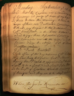
2015-01-07 15.49.56When wading through account books, muster rolls, and other dry military records, I don’t usually get a sense of the author—there might be a name jotted down, or maybe some distinctive handwriting, but hardly any evidence of personality. Reading through a 1758 orderly book from the Oneida Carry was much the same: a recounting of paroles, provisions, parades, and troop preparations. And then, curiously, tucked between the routine orders and work details, on the bottom of the 51st page:

When This You See Remember me.[1]

An—abruptly elegant—personal appeal hidden in the middle of a bureaucratic record, a record covering the various minutiae of one regiment of the vast British military apparatus but containing no information (other than a name) about the man who had chronicled them all. What on earth was it doing here?

This post began as a simple question about the meaning of private voices in the state record and quickly became something a little more meandering—tracing a phrase, finding its ubiquity in the British Atlantic, and then, in that broader context, pondering how and why it came to be on the page of an official military document. Continue reading

Guest Post: Disaster, Death, and Distilleries

Today’s guest post comes from Jordan Smith, a PhD Candidate in Atlantic History at Georgetown University. His dissertation, “The Invention of Rum,” investigates the development and production of rum in the seventeenth and eighteenth-century Atlantic World.

Warning: This post contains graphic accounts of industrial accidents.

RumOn a recent research trip to Barbados, I stopped by the Mount Gay Visitors Center. There, between tastes of a variety of rums, tour guides regaled me with a heroic tale of Barbados’s place in the invention of rum. Afterwards, I was handed a brochure which proclaimed Mount Gay to be “the rum that invented rum.” The reasoning for this marketing strategy is simple enough—Mount Gay is one of many distilleries that makes a financial killing off of linking their product to a happy history of ingenuity and originality. Yet accounts of eighteenth-century distillery disasters suggest that this invention and innovation of rum was often undergirded by shocking violence.   Continue reading

A Beginner’s Guide to Mapping Early America with Basic GIS

QGISOver the past couple years, friends have asked me a lot about maps and mapping software—questions I probably have no business fielding. I’m not truly formally trained in GIS, I’ve picked up a lot of things online, from books, in workshops, but mostly through trial-and-error, and half the time I still prefer to draw my maps by hand. (Yes, I like to draw.) It’s sort of like the four-eyed leading the blind.

There’s a reason, though, that my friends have few other places to turn. Workshops at universities, as well as many guides online, are still largely geared towards those working on more contemporary history, and to those looking to manipulate census and other large data sets. For those of us working on colonial America—especially those working on frontiers, borderlands, and native grounds—our materials rarely support this kind of work.

As I thought about my post the last couple days, I realized I wanted to write something less to those also working on spatial-intensive projects, and something more for those—like my friends—looking to find quick and simple ways to add maps to presentations and papers. In other words, those who aren’t about to download ArcGIS, run windows on their mac, enroll in a series of workshops, lose days (weeks and months) to inputting vector and raster data, and become geospatial pros. Those who are more interested in manipulating a historic map than creating a new one from historic data. Casual mappers and prospective weekend warriors of geohistorical analysis, this is for you. Continue reading

The Documentary Record on Fire and Reading Intentionality

NewYorkCapitolFireRemains

On March 29, 1911, a fire tore through the New York State Capitol Building. From the third floor of the Assembly Library, where books and papers served as kindling, it shot up to the capitol’s iconic towers. By the early morning, much of the building was in ruins, and many of the books and manuscript papers housed within it reduced to melted ink and char.

Anyone who’s used the Papers of Sir William Johnson knows the fire well. Every other page is a reminder of the embers that destroyed letters, accounts, conference minutes. It’s also a reminder that the current documentary record has been shaped in ways that—while often times hidden away—were also bright and fiery and loud. Continue reading

Taking Print from Print Culture & Leaving the Public Sphere Behind

Or how to make a causal argument about print, media, and communication in the eighteenth century

This post began as a brief response to Tom’s recent piece on the public sphere and to the conversation it generated in the comments section. As it turns out, brevity is not my strong suit, and I’ve got a few bones to pick. So all cards on the table: I’m more than a little invested in the importance of communication; I have a hard time watching print be stripped of its mechanistic or causal role; and I don’t believe we can possibly ever argue that changes in media didn’t cause social and political change.[1] Continue reading

Sinews of Power and Those Power Forgot

A Call to the Most Bland and Boring Pieces of Paper You’ve Ever Skipped Over in the Archives

VouchersReceipts

Vouchers! Receipts! Bills of exchange!

The paperwork of empire, particularly that of credit and finance, is probably not what gets most of us up in the morning. In the archives, we skip over the dull sections of the finding aids—warrants, no thanks!—and instead dive into correspondence and maps and bound volumes and clippings. The more adventurous of us might even call up account books—but those individual receipts? They’re lucky if we ever take them out of the box.

And why would we? Unless we live in a world of down-and-dirty finance or economics or material culture, they seem not only besides the point, but, even more, incredibly hollow. What do we get from reading a quick statement that someone was eventually paid for delivering a barrel of pickled cabbage in 1760? Especially when we can read in frantic detail the correspondence about how that barrel fell into the Mohawk River, burst open, got hauled back onto a bateau, arrived at Fort Stanwix, was re-opened, reeked, was declared unfit for consumption, continued to reek, was declared fit for consumption, reeked some more, ordered northward to Oswego, reeked still, and finally was delivered to a garrison comprised mostly of Germans who (our correspondents assumed) would think they’d been gifted sauerkraut.[1]

It’s the correspondence, we might argue, that gives us actors and action. In it, even a barrel—brown, wooden, boring—becomes something dynamic.

But who delivered that barrel? How long did it take him? Where did he begin his trip? Was he a merchant contractor, a militia man, a professional sled driver? And what did he get out of a journey, in the dead of winter, through the type of paralyzing cold you can only feel in upstate New York, with barrels of spoiled pickled cabbage?

Exceedingly important questions like these suddenly make the boring, bland, bureaucratic paperwork appear just a little (a very little?) more interesting. Continue reading

Rethinking the Early American Map

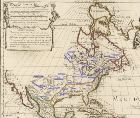
AmeriqueSeptentrionaleIt’s time we remake the North American map.

Open up most any early American history book and flip to the list of tables and figures. Chances are you’ll find—if provided—maps devoid of almost any indigenous peoples. If the book is more recent, perhaps instead you’ll find that the author included two maps: one of European settlements, and one of Native American peoples. Or, just maybe, you happen to have on hand one of the few books to merge all of these together. But look closely and see if you can find the usual tension—an unbalance resulting from the projection of European empire on one hand, and the illustration of limited, isolated, scattered indigenous nations on the other.

How can so many maps of colonial North America display European power and political influence, but not do the same for American Indian polities and groups?

Maybe the better question is, how can we overcome our own historiographical strictures and the limitations of seventeenth and eighteenth-century maps to better portray the American landscape?

Continue reading

Research in Timelines

TimelineMethodology and note-taking have been popular topics at The Junto, opinions and preferences ranging from Rachel Herrmann’s defense of good-olde-fashioned index cards, to Michael Hattem’s detailed tour of his digital workflow. I’d like to throw my hat into the ring and suggest yet another tool: timeline software.

I’m a visual person, and while a table is technically a “visual,” nothing makes me happier than seeing those rows and columns transform into something a bit more appealing.

Minor admission: I’m years late to the timeline game. But since I began using chronology software this summer—having finally leaped into the archives with little more than a macbook and a dream—my master timeline has become my best friend, my go-to reference guide. Why? Because timelines gives me easy access to, and visualization of, each and every who, what, where, and when of my project. And then some. It’s my very own personalized tool to quickly know (or estimate) where any individual or object in my project is at a given time.

Continue reading

The Plains of Abraham and Annus Mirabilis

Or, how I came to realize my early America might not be so quintessentially American. Year Fifty-Nine Song

According to my calendar—everyone has alerts set to eighteenth-century military actions, right?—today is the 254th anniversary of the French surrender of Quebec. Forget Constitution Day, this is the hottest event of your week.

Continue reading